
First off, congratulations for looking at a picture of a sidewalk and thinking “that looks interesting” – you may be in a small but important group of people!
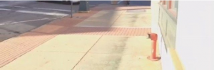
The truth is, sidewalks (like many local government services) are often overlooked or forgotten about because they aren’t the flashiest topic. However, a lot of foresight and planning is put into these sidewalks by people, like the engineers in Salisbury, so that the citizens they serve can get around a little bit easier. For example, sidewalks are built on a 2° slant so that stormwater will run into the gutter, instead of collecting in a puddle that hungrily awaits your brand new shoes. Further, the incline of a sidewalk ramp cannot be greater than 8° for wheelchair access. Oh, and the truncated domes that stick out right before a crosswalk – those help people with vision impairments know when they are about to cross the road. Admittedly, I think most of these features are required for ADA compliance; however, I felt it was worth pointing out the small details that go into making everyone’s commute a little easier. Sidewalks – you don’t think about them (or their features) until they aren’t there.
Just so that you don’t think life in Engineering is all about sidewalks, I’ll move on to some GIS (Geographic Information System). You may recall that I used GIS while with the Planning Department. Well, here it is again, and in case the message hasn’t come across – GIS IS HELPFUL IN MANY WAYS TO LOCAL GOVERNMENTS, SO GO LEARN HOW TO USE IT! Seriously, if you can take a class, you should. I plan on taking one next spring myself.
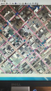
Ironically, one of my GIS projects involved…drumroll please…SIDEWALKS (right when you thought you had escaped). The Engineering department is updating the GIS Sidewalk layer to show sidewalks that have been added since the last aerial imagery was taken by Salisbury in 2014. Using the newer aerial imagery from 2018, I traced out every new sidewalk on public streets that I could find (cross your fingers that I got them all), which can then be viewed for various purposes, like tracking sidewalk cleaning.
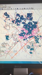
For my other GIS project, we move slightly off the sidewalk…and onto the curb. Actually though, I used the aerial imagery (and Google Street View when harder to see) to highlight every Salisbury street that has a curb or gutter. This layer (pictured below) will eventually be used to help with street cleaning, insuring that every known curb/gutter and corresponding drain are free of debris so that the stormwater system can work properly.

Engineering may not be in my wheelhouse, but I certainly enjoyed my time in the department. At the very least, it made me appreciate the little things that make a town better for the people that live in it. And yes, I do like sidewalks! What gave it away?
I will never look at sidewalks the same way again!